

Virginia’s Northern Neck is a coastal peninsula that begins in the upland forests of Westmoreland County and gently dips some 60 miles southeast to the Chesapeake Bay. It is a place laden with history and long revered for the character of its people, many of whom fashioned the political and mercantile building blocks of our nation. Indeed, Virginia’s Northern Neck is the birthplace of Presidents George Washington, James Monroe, and James Madison, and the ancestral home of General Robert E. Lee.
It is also a place that has managed to retain the scenic features of its past, when great plantations were carved out along the Coan River, Dividing Creek, and, eventually, the entire shoreline. This is partially due to its remoteness from large, metropolitan centers to the north and south, and partially due to a long legacy of farmers and watermen who have chosen to stay here, earning their livelihood from the vast reaches of croplands and surrounding waters.
Today, much of Northern Neck life is still closely tied to the fields, forests, and creeks of the Potomac and Rappahannock watersheds. Here, you can still witness the familial habits of great blue herons feeding their young at home, near Bush Mill Creek; or come across the delicate yellow bloom of the sensitive joint vetch, silently marking one of its last recorded stands in Virginia amid a carpet of marsh grasses along the Rappahannock; or quietly admire a pilot’s adept handling of a ship full of menhaden coming into dock at Reedville. In Reedville, and in countless other picturesque villages dotting the peninsula, you will be reminded of days gone by.
Physical and Natural Features
The Northern Neck is the northernmost peninsula of Virginia’s coastal plain, a sloping plateau that begins along a “fall line” intersecting Baltimore, Washington, Fredericksburg, and Richmond before continuing eastward to the submerged edge of the continental shelf.
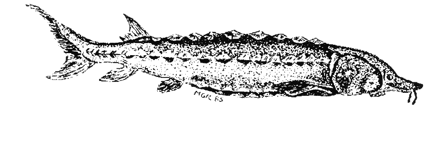
This prehistoric-looking fish, the Atlantic sturgeon, was once a familiar sight in the large rivers that border the Northern Neck.
The land is bounded on the north by the Potomac River; on the south, by the Rappahannock; and on the east, by the “Mother of Waters,” the Chesapeake Bay. While many folks consider King George part of the Northern Neck, this Guide focuses on the four eastern counties—Westmoreland, Northumberland, Lancaster, and Richmond—spanning close to 740 square miles. The counties were named after the birthplaces of the settlers who ventured from England across the Atlantic in the early 1600s. The rivers that cut into the peninsula, on the other hand—the Corrotoman, the Totuskey, the Yeocomico, the Nomini, the Wicomico—pay tribute to the Powhatan peoples whose ancestry goes back to the Woodland Indians who frequented these shores before European arrival.
Take a look at an aerial photo of the Northern Neck and you’ll see that a maze of inlets, creeks, and streams feeding into larger tributaries form the most dominant physical feature of the peninsula. The extent of land surface either permanently or periodically inundated with water is so extraordinary, in fact, that it’s a wonder anyone without webbed feet has been able to make a living here. This water network, more than any other natural feature, has shaped the area’s cultural history.
Waterways were vitally important to the indigenous tribes of the Powhatan Chiefdom that settled along their banks. They allowed the settlers to take full advantage of the food, transport, and lookout points afforded in an otherwise thickly forested land. Branching creeks and rivers later hindered the foot soldier as he marched northwest from Heathsville during the War of 1812, challenged more than a few civil engineers in the business of road building, and created a fiercely independent, self-reliant population. Places like Kinsale, Reedville, Sharps, and Leedstown all derived their economic livelihood from this bounty of water, relying upon the rivers and Bay for transportation and commerce.
Along the Rappahannock, look for evidence of early wharves whose decaying pilings are still visible at low tide. As you travel along country roads today, look for the remains of old grist mills once powered by the many ponds that still dot the landscape. One particularly well-preserved mill sits off Route 3 just outside Kilmarnock.
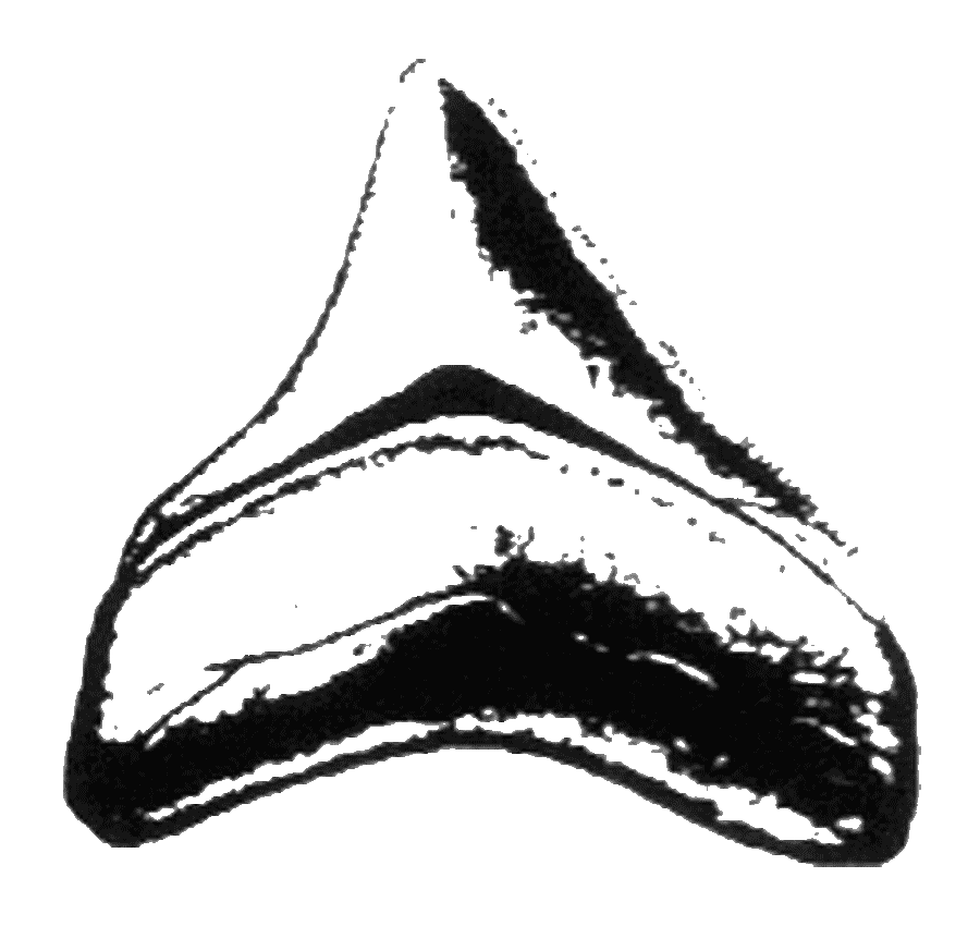
This tooth from a great white shark that once roamed in bay waters, is one of many fossils found along the cliffs at Westmoreland State Park.
The waterways and the land they divide have changed dramatically dur- ing each round of nature’s ongoing wrestling match with the glaciers. According to Woody Hobbs at the Virginia Institute of Marine Science, the Chesapeake Bay we know today is actually in its eighth “contention” and is still filling in by a sea that is rising at about one-tenth of an inch each year. The Northern Neck, like much of the coastal plain, is quite literally a wedge of sediments and seashells that has been deposited over the eons during periodic invasions and subsequent retreats of the ocean, bay, and its rivers. In some places in Westmoreland County, it covers the underlying bedrock more than 1,000 feet deep.
A long geological history of water massaging the land and leaving behind very fine, alluvial deposits explains why the Northern Neck today exhibits so many different soil types. Soil surveys for the region include a real hodge-podge of sediments scattered over three basic topographic regions: uplands, cliffs, and lower “riverine necklands.” A modern-day explorer will locate evidence of several geologic eras, starting with sands and gravels deposited during the past 15,000 years, called the Holocene Age, mixed with similar deposits from 15,000 to two million years ago, of the Pleistocene era. Beneath these shifting sands and loams and clay subsoils is crystalline bedrock, which has been neatly holding things together for more than 230 mil- lion years.
Plenty of sand separates the lacework of creeks and marshes and streams and wetlands in lower elevations. Ask any old-timer who remembers what early road travel was like in these parts, and you’re likely to unleash a spate of stories full of adventure and humor. Even the “corduroyed” roads, made of wood poles laid side-by-side and covered lightly with soil, rarely guaranteed safe passage during wet weather. Elevations in low-lying areas, after all, reach only a few feet above sea level.
Climate, of course, is closely influenced by water. Between the “River of Swans” and the “Quick Rising River,” to roughly translate the Indian names given the Potomac and Rappahannock rivers, temperatures range between 27°F and 47°F in January, and between 67°F and 87°F in July. The Northern Neck enjoys a long growing season, extending to 190 days throughout the western uplands, and another 22 days in Lancaster County. Recorded precipitation is ample for the thousands of acres under cultivation—about 43 inches each year. For those interested in weather statistics, snowfall is officially averaged at 17 inches annually for the region. Closer to the Chesapeake Bay, the pervasiveness of surface water can make for sticky, humid conditions dur- ing summer but generally milder winters.
The Early Cultural Landscape
Archaeological digs have revealed evidence of humans here as early as 8,000 to 10,000 B.C. Spearhead points and pottery remains are frequently plowed up in waterfront farmlands. Many have been identified as those used by the Clovis people, who migrated to the coastal plain from Colorado and other western states. During this time, the thick hardwood and pine forests of the watershed grew unabated—interrupted only by winding creeks or streams. After migration of the Algonquian-speaking peoples to the region (“Powhatan Indians,” as they were called by the English colonists), isolated pockets of the expansive forest began to resemble modern-day parks. The Algonquians cleared understory for better deer browsing and hunting, carved out fields for the growing needs of their communities, and cut footpaths through the forest cover. According to historian Helen Roundtree, the Indians lived a comparatively simpler material lifestyle—one in which the shells from oysters and clams often substituted metals and stones in the construction of “dugout” canoes.
 According to early records, as many as eight tribes lived on the Northern Neck. Villages were established along the rivers’ shores, home to the Moraughtacund, Nomini, Pissaseck, and Rappahannock, among others. These early Virginians had the best of everything: a diet rich in small and large game, supplemented during the warmer months by fruits and berries of the forest as well as the succulent offerings of the Chesapeake.
They were also quite resourceful in the practice of cultivating crops. Their techniques included inter-cropping, a method of planting two or more crops in the same row, which effectively conserves nutrients in the soil. Other practices included plowing “in the round” to control runoff, and using the remains of fish (most likely menhaden and other herring varieties from the Bay) as an organic source of fertilizer.
These early farmers were pushed farther into the woodlands and, perhaps more importantly, farther away from water access with each incoming wave of colonial settlement. Early settlers were sent to the region by King Charles to take a gamble on the new land and, in return, offered large land patents. Many of the first colonial settlers were, in fact, refugees from St. Mary’s City, Maryland, who crossed the Potomac during the days of religious dissension between the Puritans and the Protestants and Royalists.
 Settlement patterns quickly resembled those along the James and York rivers: land at the river’s edge was chosen first to take advantage of water access for crop transport. When the riparian parcels were gone, land was divided farther inland, and the tribes pushed even deeper into the interior.
Unique to Virginia’s Northern Neck was the ensuing pattern of land ownership after Charles II succeeded Oliver Cromwell to the English throne. Vast holdings underwent a change of title during the late 1600s and early 1700s, when they were given to the new king’s faithful followers who had stood by him during his exile in France. Seemingly overnight, the land between the Rappahannock and Potomac became known as the Northern Neck Proprietary, managed by a team of men who collected “quitrents” from previous owners turned tenants. Depending on circumstance, a skillful and fortunate land agent could amass large holdings and thus quickly accumulate wealth. This development in colonial history on the Neck had decisive, long-term impacts on the division of land. For more on this topic, read Miriam Haynie’s The Stronghold: A Story of Historic Northern Neck of Virginia and Its People.
Effects of Settlement
When Europeans first arrived in Virginia, an estimated ninety percent of the land was covered in trees. Pines grew alongside the mighty chestnut, black walnut, hickory, a variety of oaks, and other hardwoods. Lower reaches gave rise to the knobby-kneed bald cypress tree, which is today found only occasionally in tidal wetlands. It was not long before these first colonists began to fell timber and turn the soil into large farming operations.
The crop of the day was tobacco. It quickly became the mercantile lifeline to England, and markets sprang up along every major coastal river as English demand continued to rise. Farmers farther inland filled barrels, or “hogsheads,” full of tobacco leaves, attached spikes to each end, and used oxen or mules to pull them along rolling paths to the closest wharf. The rivers quickly became conduits of products, profits, and progress. But it was not long before the demanding thirst of the tobacco plant robbed the soil of its nutrient base, forcing a new generation of farmers to try their hand at other crops.
Like the history of farming, the history of early timbering is full of drama. The hardwoods were valued for their economic return by a community of Europeans whose native forests were all but gone, and then cleared by early industrialists who jumped at the opportunity afforded by a network of rivers right at their feet. Small timber operations sprouted across the Northern Neck, as they did throughout the coastal plain. They often depended on makeshift, portable mills. Trees were cut on site using steam power, and then hauled by mule and wagon to the river’s edge to be pushed down a chute to a large wharf below. From there, the massive trees were loaded onto awaiting barges, called “lighters,” headed for Chesapeake Bay and points beyond.
The speed and volume of deforestation during the 18th and 19th centuries permanently changed the character of the region’s rivers. Relatively deep-channeled waterways became silted thoroughfares flowing through denuded banks of marl and clay. Commercial points upriver, like Leedstown on the Rappahannock, felt the effects most painfully as the promise of continued river transport, on which they depended, became buried under too many feet of silt.
A Johns Hopkins University study estimates that as much as 80% of the indigenous forest of the Chesapeake Bay watershed was felled by the year 1880—converted to tobacco and grain production. And while natural growth cycles continue to change the face of the remaining forest (as slower-growing hardwoods push out the faster-growing pines, for instance), we have never recovered the breadth and variety of trees available when the region was first colonized.
The English traditions of owning and expanding territories directly opposed the traditions of local tribes, whose members did not practice the concept of ownership. This cultural collision ultimately displaced the native population of the region during the 1600s.
Today’s Northern Neck is home to about 51,000 people. Farming, fishing, and forestry still dominate the local economy, but the region is slowly accommodating small businesses and expanding service industries. Tourism-based enterprises, specifically outdoor and eco-tourism initiatives that capitalize on the area’s spectacular natural resources, are expanding.
Of Steamboats and Horses and Life on the River
Reminiscing about life on the docks of Kinsale, a harbor town on the Yeocomico River, back in the early 1900s, Florence Norris talked about a few trips she made by steamboat to Baltimore. Her first ride was with her mother when she was five or six years old. “I remember traveling on a steamboat. I had never seen a bunk bed before, and I wanted to sleep up on top, and Mom wouldn’t let me ’cause she was afraid I would roll out…I can remember the dining hall—the big room and all the tables, because it was all so big and very fancy.”
The dock was a child’s entertainment and a man’s livelihood in those days. On Sundays, Florence often went down and watched the magnificent boat come in. “Folks on the boat would pitch pennies to kids on the dock,” she said.
Schedules and important events like weddings were arranged to coincide with the steamboat’s arrival, she added. Her in-laws, for example, were married quite early in the morning, as the sun was coming up, so they could catch the boat to Baltimore for their honeymoon.
***
Walter Norris, Sr., vividly recalled how quickly life changed in Kinsale when the great storm of 1933 brought waters so high, that the bridge was swept away. Kinsale, at the time, was the site of several tomato canneries. Three cannery owners hired Walter to ferry workers across the harbor in his little 12-foot rowboat. They offered him 3 cents apiece, or $9 a week.
The young teenager could take as many as six men across at a time, and worked most of the morning transporting peelers and other day laborers to the factories. After a short afternoon break, he’d get busy bringing them back home.
It was August, and Walter continued this job for about two weeks, until one of his employers complained that 3 cents was too much. So Walter continued his ferry operation on his own. He charged a nickel a ride, earning up to “Fifteen dollars a week!” he said with a smile.
As a young man, Walter worked for the general store, about ten miles outside of town. He traveled by horse and buggy to work. One day on his return trip, he fell asleep. “When I woke up,” he laughed, “I was back home in the stable, and the horse was standing still, waiting. He sure knew his way home, I guess.”
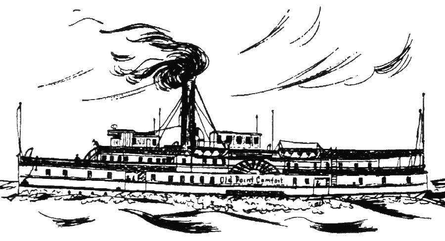
Steamboats were a familiar sight on the Potomac and Rappahannock from the late 1800s until the 1930s.